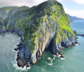
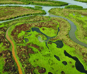
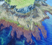
Here in Prince William Sound we often hear about new technological tools, environmental studies, examinations of the weather or the coastline. But we don’t often get to see what the tool does, look at the data used in the study or get access to the results for our own uses. The ShoreZone project has a public website that gives us that opportunity and some amazing images. http://www.shorezone.org/
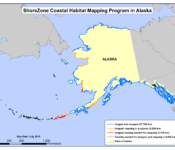
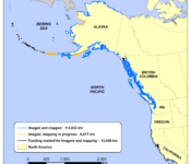
ShoreZone is a research partnership that has imaged and mapped coastal habitats of Oregon, Washington and British Columbia and has now completed 92% of the Alaska coast. The partnership includes global information system specialists, web specialists, nonprofit organizations and provincial, state and federal government agencies. Partners in Prince William Sound include Prince William Sound Regional Advisory Council, Prince William Sound Science Center and Oil Spill Recovery Institute. The images can be used to aid oil spill recovery, environmental studies, rescue efforts; the possibilities are enormous.
The web site shorezone.org will teach you how to use shorezone and suggest things you might want to use it for.
Topics for types of use listed on the web site are,
- Clues to the Past- Archaeologist Martin Stanford spends time in the winter season poring over ShoreZone videos and photos with the aim of uncovering clues about the past, like the stone fish traps and weirs built approximately 600 years ago that he noticed from studying a ShoreZone photo.
- Storytelling in a Digital Age- Students in Kaktovik made a film which has been invited to several film festivals. In ‘Weather or Not’, Tracey and Brittany Burns interview Elders about the changes in the coast line over the years, using images from ShoreZone to illustrate current conditions
- ShoreZone in the Class Room-In Barrow, ShoreZone team members and educators worked together to develop a middle school science unit that combines modern tools like the ShoreZone database with traditional knowledge gathered from Elders in the community.
Excerpted from ShoreZone.org
When asked about possible personal uses, Jeremy Robida (whose contribution on behalf of RCAC appears below) cited some recreational ideas, saying he has used it to investigate fat bike routes along beaches and that he thought it would be useful to kayakers looking for a haul out camp site and possibly for planning hunting trips.
Jenny Heckathorn, who currently teaches Biology 1, Honors Biology, Anatomy & Physiology, College Marine Biology, Forensic Science among others at Valdez High School, said, she had been aware of these mapping efforts from the beginning and had seen a presentation at a National Association of Marine Educators.
Lee Hart of Levitation 49 had this to say, “Tools like Shorezone.org give planners an opportunity to forecast and plan for things like rising sea levels, glacier melt, etc. while giving teachers a cool tool to help students better understand their local environment.”
According to A Coastline Online, a video produced by environmental group 360.org, the project started over 35 years ago with flyovers along the British Columbia coast. (link to video http://www.360north.org/shorezone/ ) Still photos and video were shot from a plane with detailed notes and sketches done by hand. The project steadily grew from there. The huge undertaking of mapping the Alaska coast, which is over half of the total coastline of the United States, began after the Exxon Valdez oil spill drew attention to the need and the DEC was tasked with pinpointing sensitive areas like beds of eel grass for special protection during a spill cleanup. The first such use was in 2001 when the wreck of the Princess Kathleen was recovered off Point Lena near Juneau due to the danger of leaking bunker oil to the local habitat. 130,000 gallons of petroleum product was salvaged from the wreck.*
|
|
“ The Shorezone effort in Alaska was begun by the Cook Inlet Regional Citizens’ Advisory Council because they recognized the value of having maps of intertidal habitats that could be impacted by an oil spill. It soon became obvious that the pictures and video collected were also valuable for logistical planning. It is good to know what the beach will look like at low tide. (I would love to have a matching set of video at high tide as well.) The geographical response strategies developed by the state need to know what the coastline will look like through the tidal cycle. The position of the water in the video provides a look at the low tide situation. You can also use the video and pictures to get an idea of where the high-tide line is as well.
“Geological and biological information is collected during Shorezone mapping. The geological data can provide an indication of how likely oil is to be trapped in a section of coastline. The biological information provides a snapshot of what to expect. The biology of the intertidal zone tends to change fairly dramatically between years. We have supported some work to look at methods to provide some temporal information about the biology to go along with the great maps from Shorezone”
Scott Pegau; Oil Spill Recovery Institute
Jeremy Robida of Prince William Sound Regional Citizens Advisory Council listed some of the potential uses of the program:
- understanding where marine debris would likely end up,
- better imagery for search and rescue functions,
- tracking coastal erosion,
- archeology,
- scientific research, and
- actual spill response functions such as
- 1) understanding what a given beach surface is like (rocky cobble or sandy, etc) as this would influence clean-up and protection strategies,
- 2) better understanding if a given beach is suitable to land a vessel on, or
- 3) better understanding habitat and wildlife related themes.
- There are also spill response planning functions that ShoreZone is useful for too such as:
- helping to pre-identify sensitive areas
- access to better imagery to look ahead before doing a spill drill exercise for example in a new area.
He said that PWSRCAC is definitely interested in SZ and has supported the project and it’s evolution through the years.
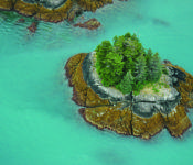
All photos and maps courtesy of ShoreZone
*The steamer Princess Kathleen was built in 1924 and started life as a combined passenger/freighter. When it ran aground off Point Lee in 1952 it was a cruise ship traveling the inside passage from Vancouver to Alaska. The wreck of Princess Kathleen sat in approximately 50 ft of water and was accessible to divers, but strong tides and currents made salvage impractical at the time. https://en.wikipedia.org/wiki/SS_Princess_Kathleen_(1924)
Thanks to Kelly Ingram and Dustin Solberg of The Nature Conservancy for their help.
